Event Course, Route Maps & Profiles
-
Riders route directions from Start to Finish –
Stage 1 – Start to Midway Point (Transition & Reuel Station 1):
Leave Outram heading South on SH87 – turn left onto Old Dunstan Road – turn right onto Upper Taieri-Paerau Road – turn left onto Linnburn Runs Road.
Stage 2 –Midway Point (Transition & Reuel Station 1) to Finish:
Head South-West along Linnburn Runs Road – turn right onto Old Dunstan Road– turn left onto Aston Road [site of 3/4 Stage Point (Refuel Station 2)] – turn right onto Poolburn-Moa Creek Road – turn left onto Crawford Hills Road – turn left onto Galloway Road – turn left onto Lower Manorburn Road – turn right onto Tucker Hill Road extension (Note: Riders are prohibited from riding the Rail Trail. Riders must ford the Manorburn Stream) – continue on Tucker Hill Road extension – cross Little Valley Road onto Graveyard Gully Road – turn right and cross Shakey Bridge – immediately turn left of the bridge onto the path leading to the Linger & Die Reserve – cross the reserve and cross Rivers Street onto Centennial Park. -
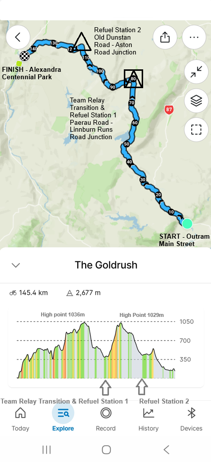
THE GOLDRUSH - Full Map & Profile
For the Full 145km Course Route Map & Profile, click here
-

Stage 1 - 80km Profile & Map
For the Stage 1 Team Relay Route map & Profile, click here
-

Stage 2 - 65km Profile & Map
For the Stage 2 Team Relay Route map & Profile, click here